


The 250th anniversary of the United States has arrived, and to mark the occasion, the U.S. Geological Survey (USGS) has unveiled a new satellite image of the country alongside one from 1976, highlighting the dramatic changes the American landscape has undergone over the past 50 years.
The satellite image is part of a series of America250-related projects. Created using data from Landsat 8 and Landsat 9, it represents the latest chapter in a tradition that began half a century ago, when satellite imagery first gave Americans a new way to view their country, according to the USGS.
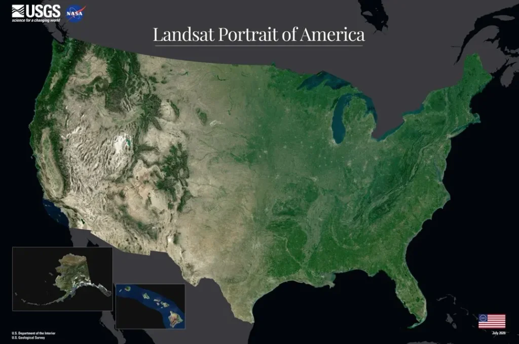
The mosaic stretches from the rainforests of the Pacific Northwest to Florida’s Everglades, and from the peaks of the Rocky Mountains to the agricultural heartland of the Great Plains. The agency said the 2026 image reflects five decades of progress in Earth observation and offers a fresh perspective on the nation’s landscapes in celebration of the semiquincentennial.
America250 from Space
Landsat is a series of Earth observation satellites jointly managed by NASA and the U.S. Geological Survey (USGS). The program began in 1972 with the launch of Landsat 1 and continues today with Landsat 8 and Landsat 9. Fifty years ago, to commemorate the U.S. Bicentennial, the July 1976 issue of National Geographic featured the first Landsat photomosaic of the contiguous United States, titled “Portrait U.S.A.”
“The image gave millions of Americans a new satellite perspective of their country and demonstrated the potential of Landsat’s emerging Earth observation record. It proved that satellites could serve both as a scientific record and as a new way of seeing the American landscape,” the agency said.
The new 2026 portrait continues that tradition. While the 1976 mosaic introduced a groundbreaking view of the nation, the latest image illustrates how five decades of continuous observations, improved sensors, and advances in image processing have deepened our understanding of the American landscape.
Creating a seamless, cloud-free portrait of an entire nation is no easy task, the USGS explained. The agency said the mosaic was produced by analyzing billions of pixels from Landsat 8 and Landsat 9 stored in the USGS Landsat archive. For each location, cloud-free observations collected during the growing season were compared, and the pixels that best represented typical conditions were selected to create the final image. The finished mosaic was then overlaid on elevation data to add depth and contrast.
The United States from 1976 to 2026: Half a Century of Change
One of the most striking differences between the two images is color. The 2026 image features vibrant shades of green across the eastern United States, while beige and brown tones dominate the West, reflecting the region’s drier conditions. By comparison, the 1976 image has a more muted color palette.
Another noticeable change is the shrinking of Utah’s Great Salt Lake, caused by reduced inflows from its tributary rivers due to prolonged drought, rising temperatures, and heavy water use for agriculture, industry, and growing urban areas.
The map also underscores Landsat’s importance over the past five decades as a vital tool for resource management and scientific research. Its imagery is used to monitor crops, water resources, wildfires, floods, and other natural events, while also documenting changes in forests, wetlands, coastlines, urban areas, and agricultural lands.
With its extensive historical archive, Landsat provides an invaluable record of how landscapes have evolved, helping scientists better understand environmental change and supporting informed decision-making for the future. That legacy will continue with the launch of Landsat 10, scheduled for 2031.