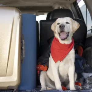
Llame al (888) 572-7520 para hablar con un agente

A historic cold wave is set to disrupt ground and air transportation across the United States, bringing cancellations, delays, and operational restrictions to highways, airports, and essential services throughout the weekend. Federal authorities have activated emergency plans in response to a major winter storm expected to deliver snow, ice, and extreme temperatures to large portions of the country.

The U.S. is heading into a weekend marked by widespread transportation disruptions as airports across the Central and Northeast regions implement special operating protocols, while roadway officials warn of extremely hazardous travel conditions in multiple states.

The winter system, continuously monitored by the National Weather Service (NWS), will combine heavy snow, freezing rain, sleet, and dangerously low temperatures across an area spanning more than 3,200 kilometers (2,000 miles). According to official forecasts, it ranks among the most severe winter events of the past decade, both for its geographic reach and the persistence of extreme cold—factors likely to prolong impacts on roads, airports, and basic services.

Emergency measures and public guidance

In response, federal, state, and local authorities have activated emergency response plans and reinforced essential services. The NWS and the Federal Highway Administration urged the public to avoid nonessential travel, particularly during peak storm periods, and to stock up on basic supplies for several days. At the same time, maintenance crews are working proactively on road clearing and preventive treatment, while utility teams are strengthening efforts to protect the power grid against potential prolonged outages.

Across several jurisdictions, school districts and public offices announced precautionary closures to limit circulation and reduce risk. Local governments are maintaining updated information channels so residents can follow real-time advisories, recommendations, and forecast changes.

Areas with the greatest impact and expected snowfall

According to the NWS, the heaviest snowfall will concentrate in mountain regions of the Southwest and in urban areas across the Central and Eastern U.S. In Flagstaff and areas near Telluride, forecasts indicate accumulations of up to 60 centimeters (24 inches).

Across the Southern Plains, cities such as Oklahoma City could see more than 30 centimeters (12 inches) of snow. In Dallas, Fort Worth, and Plano, expected totals are lower, ranging from 2.5 to 7.5 centimeters (1 to 3 inches). As the system moves northeast, authorities anticipate higher totals.

In the Mid-Atlantic, the NWS warned that Washington, DC, Richmond, Norfolk, and parts of Philadelphia could exceed 30 centimeters (12 inches) over the weekend, noting that final amounts may vary depending on the storm’s ultimate track—particularly near the northern edge.

Outlook for the Northeast and Southeast

The Northeast remains under alert for significant accumulations. The NWS estimates that New York City, Yonkers, White Plains, and New Rochelle could receive 30 to 45 centimeters (12 to 18 inches), while inland locations such as Syracuse and Binghamton may again reach 60 centimeters (24 inches).

In the Southeast, snowfall totals are expected to be lower. Parts of Georgia and Alabama may see 2.5 to 7.5 centimeters (1 to 3 inches), though specific areas of Tennessee and North Carolina could exceed 30 centimeters (12 inches).

Risks to infrastructure, power, and mobility

The NWS cautioned that the combination of snow, ice, and freezing rain significantly raises the risk of power outages and roadway accidents, particularly in southern and southeastern states such as Texas, Oklahoma, and Tennessee, where ice accumulation on trees and power lines could trigger widespread electrical disruptions.

“Travel conditions will become extremely dangerous, and widespread power interruptions are possible,” the agency warned. Emergency teams and roadway maintenance crews are already deployed in high-risk areas to ensure public safety and restore essential services if incidents occur.

Economic and logistical impacts under assessment

In previous winter storms of comparable scale, economic losses exceeded $2 billion, with major impacts on air and ground transportation, logistics, and commercial activity. For this event, authorities expect thousands of flight cancellations and delays, along with disruptions to services and supply chains across broad regions.

The NWS expects the system to continue pushing northeast and to maintain adverse effects into early next week, while noting that conditions may change depending on the storm’s final path and local factors.

Final recommendations to the public

Officials reiterated the importance of consulting official sources before traveling or planning activities. In areas under alert, residents are advised to review supplies, secure alternative power sources, and keep communication lines open with family members and emergency services. Storm monitoring will continue, with additional alerts and guidance issued as conditions evolve.


Facebook
Twitter
LinkedIn

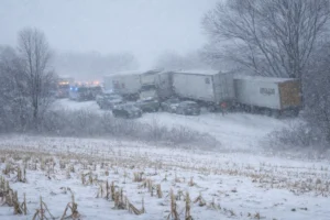
Ground and Air Transportation Brace for a Weekend of Cancellations and Delays

A historic cold wave is set to disrupt ground and air transportation across the United States, bringing cancellations, delays, and operational restrictions to highways, airports, and essential services throughout the weekend. Federal authorities have activated emergency plans in response to a major winter storm expected to deliver snow, ice, and extreme temperatures to large portions of the country.

Read More »
Polar vortex

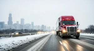
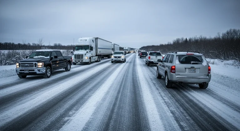
Polar Vortex Puts U.S. Roads on Alert

A powerful polar vortex outbreak is triggering a widespread winter storm across the United States, bringing snow, ice, and extreme cold to major freight corridors. The event poses a serious risk to trucking operations, road safety, delivery schedules, and commercial vehicle insurance exposure.

Read More »

Leave a Reply

Your email address will not be published. Required fields are marked *

Business hours: Monday to Friday from 8:00 AM to 5:00 PM. California time
Leave your number and a member of our company will contact you
Horario de atención: Lunes a viernes de 8.00 AM a 5.00 PM. Hora california

Deje su número y un miembro de nuestra empresa se pondrá en contacto con usted

Privacy summary

This website uses cookies so that we can offer you the best possible user experience. Cookie information is stored in your browser and performs functions such as recognizing you when you return to our website or helping our team understand which sections of the website you find most interesting and useful.

More information about the privacy policy: Privacy Policy

More information about the terms of use: Terms of use 

More information about the disclaimer: Disclaimer 

More information on acceptable use policies: Acceptable Use Policies